 PCI Geomatics was pleased to attend the 2009 ESRI User Conference (UC) in San Diego from July 11-17. The ESRI UC is a very exciting annual event, filled with industry focused meetings, technical sessions showcasing ESRI technology as well as case studies given by GIS users from all around the world. PCI Geomatics has recently become an ESRI Business Partner, so for us it was exhilarating experience to be a part of the ESRI UC for the first time. Walking into the Plenary Session, it felt like we were attending a rock concert, complete with three giant TV Jumbotrons!
PCI Geomatics was represented by Marketing, Sales and Engineering staff, all well versed in upcoming plans to launch PCI-ESRI integrated products. The ESRI staff from their US and Canadian offices were extremely welcoming, in addition to other international ESRI companies who operate independently and re-sell ESRI products in their respective markets. PCI’s message and presence were very well received.
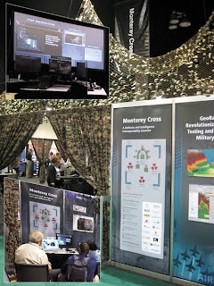
 PCI presented some of its key technologies at the ESRI UC including satellite modeling/sensor support, as well as advanced SAR processing. Booth #2018 was selected for our main exhibit due to its proximity to satellite data providers such as Geoeye, Digital Globe, Infoterra, and Spot Image. Through PCI Geomatics US, PCI participated in Monterey Cross (MX), a joint effort among ESRI and ESRI business partners that demonstrates the value of commercial off the shelf software, enterprise services, and standards-based interoperability to individuals within the defense and intelligence sectors. This unique exhibit caught the eye of many ESRI UC attendees due to its innovative concept. Upon entering the camouflaged briefing area, visitors received a 2-3 minute brief from ESRI staff or one of its business partners (e.g. PCI Geomatics) using an interactive kiosk that was designed to tell the story of MX from the war fighter’s point of view. The brief exposed attendees to innovative technologies presented by the business partners, put into application to solve different aspects of the MX battle problem; all technologies were integrated into a common battle space workflow.
In addition to the main exhibit and defense showcase, PCI co-sponsored the 2009 Remote Sensing and GIS Event, held on Sunday, July 12th. ESRI, lead by its Director of Imagery Enterprise Solutions (Lawrie Jordan), presented its technology road map which featured business partners, such as PCI Geomatics, who will provide essential multi sensor support and advanced SAR processing capabilities to ESRI users going forward. PCI Geomatics’ Chief Technology Officer (David Stanley) participated in the Imagery Software Providers panel discussion during the Remote Sensing and GIS event.
 Topics discussed included the increasing volume of data GIS users are trying to manage, and the desire to provide those users with streamlined work flows that integrate with their existing ArcGIS toolsets. A draw was held during the reception for a copy of Geomatica Core, PCI’s flagship desktop software.


