Monday, August 31, 2009

PCI Geomatics to Participate as Silver Sponsor at ISDE6 in Beijing

Richmond Hill, Ontario – September 1, 2009: PCI Geomatics, a world leading developer of geo-imaging software and systems, is pleased to announce its involvement as a silver sponsor at the 6th International Symposium on Digital Earth (ISDE6) in Beijing, China.

In addition to the silver sponsorship, PCI Geomatics will be exhibiting at booths # 140-143. Demonstrations will include the latest in high performance automated image processing and image analysis technology. PCI Geomatics will also unveil to the Asian market its new GeoConference software – a live geospatial web conferencing technology that enables groups to share and view maps and images interactively over the web in real-time.

Furthermore, PCI Geomatics will be hosting a complimentary session on September 8 entitled, "GeoImaging Solutions Seminar", which will feature the latest developments in the processing and managing of satellite imagery. Room 310, Beijing International Convention Center, 1:30 – 4:00pm.

The theme of the symposium is Digital Earth in Action, and Dr. Gordon Deng, Technical Architect from PCI Geomatics, will be presenting "Enterprise Imagery Processing and Dissemination" in the afternoon of September 11in Exhibition Hall 2. Also, in attendance at ISDE6 will be members of PCI Geomatics’ executive team, including President and CEO Dr. Robert Moses, as well as Country Manager for PCI (Beijing) Technology Col, Ltd., Mr.Yubin Xin.

"PCI Geomatics is delighted to be a silver sponsor for ISDE6, and we look forward to participating and demonstrating our business and technology advancements," said Dr. Robert Moses, President and CEO of PCI Geomatics.”

ISDE will be taking place on September 9 – 12 at the Beijing International Convention Center.

For more information on ISDE-6 please visit www.isde6.org.

About PCI Geomatics


PCI Geomatics is a world leading developer of hardware/software systems for geo-imaging solutions. Since 1982, we have specialized in remote sensing, digital photogrammetry, spatial analysis, cartographic production, automated production systems, image management and on demand mapping solutions. PCI Geomatics’ advanced hardware/software systems address a wide variety of industry applications including the environment, agriculture, security and intelligence, aerospace & defense, and satellite receiving stations. We have the expertise and know-how to turn images into useful information.

For more information, visit www.pcigeomatics.com.

Press Contact
Alysia Vetter
Marketing Manager
Tel: 819-770-0022, Ext. 233
Fax: 819-770-0098
Email: vetter@pcigeomatics.com
Web: www.pcigeomatics.com


Wednesday, August 5, 2009

IMSTRAT AND PCI GEOMATICS TEAM TO PROVIDE ENHANCED REMOTE SENSING AND GEOMATICA® TRAINING SOLUTIONS

Carleton Place, Ontario - August 5, 2009: ImStrat Corporation and PCI Geomatics have signed a Teaming Agreement, whereby both parties will participate in jointly developing and providing combined remote sensing and PCI software training programs to PCI and ImStrat clients, both in Canada and around the world.

Both ImStrat Corporation and PCI Geomatics possess complementary capabilities and products, with PCI Geomatics being a world leading developer of geo-imaging software and systems, and ImStrat Corporation as a Geospatial Intelligence Analysis and Training Solutions provider.

Tom Last, President of ImStrat Corporation said, "I'm very pleased and excited to work with PCI Geomatics on developing and delivering these training solutions. PCI Geomatica is clearly a world class remote sensing software application. However, training within key applications is critical to its continued successful use. This is where ImStrat will assist by providing complimentary image analysis training solutions."

"PCI Geomatics is excited to be partnered with ImStrat and the quality geospatial intelligence training programs they offer," said Brad Schmidt, Vice-President – Sales and Marketing at PCI Geomatics. "This agreement provides a foundation to offer an enhanced training experience for both ImStrat and PCI users to obtain remote sensing and image analysis knowledge through innovative and comprehensive training programs."

About PCI Geomatics

PCI Geomatics is a world leading developer of hardware/software systems for geo-imaging solutions. Since 1982, we have specialized in remote sensing, digital photogrammetry, spatial analysis, cartographic production, automated production systems, image management and on demand mapping solutions. PCI Geomatics’ advanced hardware/software systems address a wide variety of industry applications including the environment, agriculture, security and intelligence, aerospace & defense, and satellite receiving stations. We have the expertise and know-how to turn images into useful information.

For more information, visit www.pcigeomatics.com.

About ImStrat Corporation

ImStrat Corporation is a privately owned Canadian Geospatial Intelligence Analysis innovation solutions and training provider.

ImStrat's innovative solutions and training support programs expand the range of Geospatial Intelligence requirements. This includes, but not limited to, confidential analysis support for ISR operations, baseline intelligence product development for use in other geospatial database systems, to complete turn-key imagery intelligence analysis training support programs. ImStrat is the sole Canadian partner of DigitalGlobe Defense and Intelligence Business Unit of the United States for QuickBird, WorldView1 and WorldView2 satellite systems. ImStrat is also the sole Canadian partner of Overwatch Geospatial LLC of the United States.

To talk to our training staff or to request training, call our toll free line at 1-877-269-5940, or email your training requirements to trg@imstrat.on.


Press Contacts

Alysia Vetter
Marketing Manager
Tel: 819-770-0022, Ext. 233
Fax: 819-770-0098
Email: vetter@pcigeomatics.com
Web: www.pcigeomatics.com

Natasha Major
Administration
Tel: 613-257-5940
Fax: 613-257-8817
Email: nmajor@imstat.on.ca
Web: www.imstrat.on.ca

Tuesday, August 4, 2009

PCI Geomatics Attends and Exhibits at the ESRI User Conference, July 11-17, 2009

ESRI 2009 User Conference - Jack Dangermond speaks during the Plenary SessionPCI Geomatics was pleased to attend the 2009 ESRI User Conference (UC) in San Diego from July 11-17. The ESRI UC is a very exciting annual event, filled with industry focused meetings, technical sessions showcasing ESRI technology as well as case studies given by GIS users from all around the world. PCI Geomatics has recently become an ESRI Business Partner, so for us it was exhilarating experience to be a part of the ESRI UC for the first time. Walking into the Plenary Session, it felt like we were attending a rock concert, complete with three giant TV Jumbotrons!

PCI Geomatics was represented by Marketing, Sales and Engineering staff, all well versed in upcoming plans to launch PCI-ESRI integrated products. The ESRI staff from their US and Canadian offices were extremely welcoming, in addition to other international ESRI companies who operate independently and re-sell ESRI products in their respective markets. PCI’s message and presence were very well received.

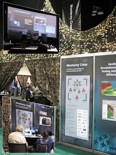
The ESRI Monterey Cross Defense exhibitPCI presented some of its key technologies at the ESRI UC including satellite modeling/sensor support, as well as advanced SAR processing. Booth #2018 was selected for our main exhibit due to its proximity to satellite data providers such as Geoeye, Digital Globe, Infoterra, and Spot Image. Through PCI Geomatics US, PCI participated in Monterey Cross (MX), a joint effort among ESRI and ESRI business partners that demonstrates the value of commercial off the shelf software, enterprise services, and standards-based interoperability to individuals within the defense and intelligence sectors. This unique exhibit caught the eye of many ESRI UC attendees due to its innovative concept. Upon entering the camouflaged briefing area, visitors received a 2-3 minute brief from ESRI staff or one of its business partners (e.g. PCI Geomatics) using an interactive kiosk that was designed to tell the story of MX from the war fighter’s point of view. The brief exposed attendees to innovative technologies presented by the business partners, put into application to solve different aspects of the MX battle problem; all technologies were integrated into a common battle space workflow.

PCI’s Chief Technology Officer David Stanley participates in a panel discussion on Image Processing

In addition to the main exhibit and defense showcase, PCI co-sponsored the 2009 Remote Sensing and GIS Event, held on Sunday, July 12th. ESRI, lead by its Director of Imagery Enterprise Solutions (Lawrie Jordan), presented its technology road map which featured business partners, such as PCI Geomatics, who will provide essential multi sensor support and advanced SAR processing capabilities to ESRI users going forward. PCI Geomatics’ Chief Technology Officer (David Stanley) participated in the Imagery Software Providers panel discussion during the Remote Sensing and GIS event.

PCI Geomatica Core giveway - Remote Sensing and GIS Event, Sunday July 12, 2009Topics discussed included the increasing volume of data GIS users are trying to manage, and the desire to provide those users with streamlined work flows that integrate with their existing ArcGIS toolsets. A draw was held during the reception for a copy of Geomatica Core, PCI’s flagship desktop software.

Monday, August 3, 2009

PCI Geomatics Appoints Past Toronto Stock Exchange President and CEO to its Board of Directors

Richmond Hill, Ontario – August 3, 2009: PCI Geomatics, a world leading developer of geo-imaging software and systems, is pleased to announce the appointment of Mr. Rowland Fleming to its Board of Directors.

Mr. Fleming specializes in corporate governance, having held key positions in Canada’s financial sector. He has served as President of the Toronto Stock Exchange, President of National Trust and Executive Vice President of the Bank of Nova Scotia. Mr. Fleming recently retired as Vice Chair of the Export Development Corp.

"We are delighted to have Mr. Fleming join our Board of Directors," said David McFadden, Chairman of the Board of PCI Geomatics. "His distinguished career in finance and his broad business experience will be very valuable assets to PCI Geomatics."

"PCI Geomatics has established a world class reputation in satellite image management, and I look forward to working with my fellow Board members on the implementation of its growth strategy," said Rowland Fleming.

About PCI Geomatics

PCI Geomatics is a world leading developer of hardware/software systems for geo-imaging solutions. Since 1982, we have specialized in remote sensing, digital photogrammetry, spatial analysis, cartographic production, automated production systems, image management and on demand mapping solutions. PCI Geomatics’ advanced hardware/software systems address a wide variety of industry applications including the environment, agriculture, security and intelligence, aerospace & defense, and satellite receiving stations. We have the expertise and know-how to turn images into useful information.

For more information, visit www.pcigeomatics.com.

Press Contact
Alysia Vetter
Marketing Manager
Tel: 819-770-0022, Ext. 233
Fax: 819-770-0098
Email: vetter@pcigeomatics.com
Web: www.pcigeomatics.com